29. mai 2008
Google Earth Plug-in Puts Google Earth in Your Browser
Windows only: The freeware Google Earth plug-in integrates Google Earth with your web browser, embedding the 3-D glory of Earth in Firefox or Internet Explorer. The results, which you can see in the video above, are impressive. There isn't a ton of Google Earth plug-in integration on the web yet, but check out the samples to understand the possibilities, like switching between Google Maps and Earth on-the-fly. The Google Earth plug-in is Windows only, supports Firefox and Internet Explorer.
15. mai 2008
Wikipedia Added to Google Maps
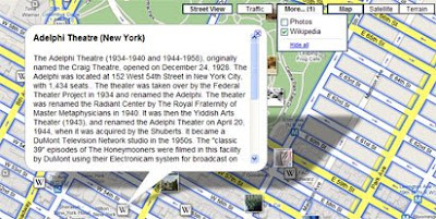
In what is proving to be another busy day for Google, Wikipedia articles have been added to Google Maps. The new Wikipedia tags can be turned on via a 'More' button that has been added to the top right hand corner of the map.

When the Wikipedia tick box is selected small 'W' tags appear on the map where Wikipedia articles are available. Clicking on the 'W' tag will open an information window containing the Wikipedia article.
Panoramio photos can also be turned on via the same 'More' button. The photos option however feels a little superfluous considering Panoramio photos were added last week and can also be turned on in the left-hand panel. Intriguingly the photos turned on by the 'More' button contain a Panoramio logo whilst the ones accessed by the left-hand side panel don't, even though both sets of photos are served by Panoramio.
Via Googlemapsmania
6. mai 2008
Mapping orienteering routes
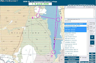
RouteGadget is web utility for drawing and comparing orienteering routes. It is Java applet running on browser and Perl scripts running on server that can be installed on any Unix, Linux, Windows server or used locally on PC / laptop. Free, no quarantees, support etc. Made by volunteer :-)
Hansapank Xdream demo:

Hansapank Xdream demo:

Digitizing on Openlayers
Digitizing on Openlayers and many other useful developers hints including GML, KML parsers etc:
- http://www.openlayers.org/dev/examples/modify-feature.html
- http://www.openlayers.org/dev/examples/
- http://www.openlayers.org/dev/examples/modify-feature.html
- http://www.openlayers.org/dev/examples/
Tellimine:
Kommentaarid (Atom)