Kuvatud on postitused sildiga Map content. Kuva kõik postitused

13. apr 2009

New web-map API services covering Baltics

We are proud to announce new WMS services and API-s:

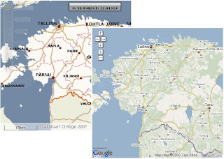
Map in WMS standard with layer control. (Coverage: Baltic, Estonia, Latvia, Lithuania)
Ortophoto (Est. Latvia in progress)

Geocoding
API with XML/JSON output.
(Baltic, Est, Lat, Lit)

Reverse-geocoding API with XML/JSON output.
(Baltic, Est, Lat, Lit)

Routing API between multiple points with XML output.
(Est, Lat, Lit. Baltic's in progress).

See level of map details at regio.delfi.ee and maps.delfi.lt For more information about API-s contact us.


1. juuli 2008

Baltic maps

Our own map and geocoding database of Baltics is finally ready and first tileset with address search is online for testing. Links to map demos:
Latvia
Lihtuania

18. apr 2008

Maporama for MC FlashTile

Now Maporama maps available for MapCat customers, click for the demo:

2. apr 2008

Google Bridge

For LBS demos we often need clobal content, more and more often "for tomorrow" and sometimes for very exotic and unexpected regions. It's not possible to integrate Navteq, Leaddog or TeleAtlas data into our GIS Engine with such short notice thus we created Google Maps support into MapCat. Google Bridge covers basic GIS functionalities (navigation, search, routing) and enables to use MapCat search, routing and light digitizing components in combination with GM (show adresses, POI's, routing results, geofences on top of the maps etc).

See also:
- Routing demo
- WMS demo
- GC Admin demo

Google Bridge is also useful for our webmap customers in Baltics who're willingly ready to pay for internetmap applications but not monthly fees for the maps (and for whom maps quality is not critical issue :-)

27. jaan 2008

GC Admin

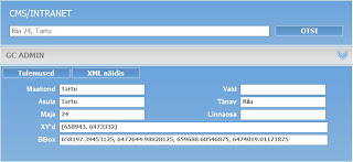
GC Admin is software for geocoding addresses and digitizing objects within 3-rd party CMS/intranet solution:


See also our GC Admin with Google Maps and integration hints:

2. apr 2007

Base maps

We use our web-mapping technology as core GIS component inside Regio/Reach-U AVL and LBS solutions that is sold worldwide through Ericsson channels. Full set of solution consists of applications, GIS engine, integration work and maps including data management work.

Some examples of base maps:
Map of Saudi-Arabia and new zoom-bar
Estonian maps within Visitestonia.com map application
Latvia (street level maps it towns 1:10.000, base map 1:50.000, ca. 315. 000 address points)
Europe general (1:500.0000)
Ukraine
Marocco
Mexico

Portugal

14. märts 2007

L-Est to WGS and vice versa

An old tool, useful for keeping in mind our future defelopment work, but irreplaceable for GPS users etc already today:

http://kaardid.regio.ee/coords/

11. märts 2007

EMT oma andmeuuenduse liides

Kunagi aastaid tagasi tegi Rainer EMT-ile Mynearest baasile on-line andmete uuendamise liidese. See tundub tänini töötavat http://lbs.emt.ee/LBData/ aadressil (kasutajanimi: regio, parooli ei julge siia panna :). Vt põhilehtede screenshotid comments alt, et funktsionaalsusest aimu saada. Liides on eelkõige tekstipõhine, ja kaardile saab detailide juurest vaid vaatamiseks.

Asi oligi mõeldud vanade objektide kustutamiseks ja nimede/kirjelduste parandamiseks, mitte niiväga kaardil uute andmete lisamiseks. Viimane on muide samas võimalik, kuid asukoht käib geokodeerimisega: pärast tekstiandmete (sh aadress) sisestust vajutad nupule "geokodeeri" ja ta annab aadressile automaatselt leitud vasted, millest saab siis õige valida. Ei mingit kaardil zoomimist ega klikkimist.