Making maps closer to real world has been in maps-makers scope for long time. What about borrowing idea of physics-law-like behaviors to web-maps form BumpTop desktop interface? It turns your desktop into a 3D space and lets you move your documents the way you would on a physical desktop.
17. okt 2008
1. okt 2008
Flash player for the iPhone?
Adobe is actively developing a Flash player for the iPhone— now all they're waiting for is the OK from Apple.
Apple may have many reasons for not allowing Flash onto the iPhone, but if anyone has a good shot at getting their technology into the device, it would be Adobe.
More from: Flashmagazine
Apple may have many reasons for not allowing Flash onto the iPhone, but if anyone has a good shot at getting their technology into the device, it would be Adobe.
More from: Flashmagazine
27. aug 2008
ArcGIS server Flex API
ESRI announced the new ArcGIS API for Flex Beta at the ESRI International User Conference in San Diego, California, which was held August 4–8, 2008. Read more at DM press release...
First look and feel is quite good, but it's really still a beta ;-)
Also listen to the podcast at the same topic.
First look and feel is quite good, but it's really still a beta ;-)
Also listen to the podcast at the same topic.
1. juuli 2008
Interactive tourism-map (KOV)
There is new map on our products line. Interactive tourism-map (oftentimes called KOV inside Regio) is a tool for local municipalities, tourism portals etc to promote POI-s, hiking-routes, nature parks etc on map. It has features like route calculation, intelligent address-search, multible map views, emailing and printing map.
Even more noteworthy are its administration possibilities: Administrator can customize whole map interface design, its measures, and behaviour of objects, depth of zoom levels etc. Of course, has total control over object (also upload pictures to POI-s), layer and groups management.

Try our public demo account:
Map: http://teenus.regio.ee/kov/index.php?id=199
Admin: http://teenus.regio.ee/kov/admin
User: „demo“
Pass: „demo123“
NB! User rights in demo are limited.
Examples of projects using KOV:
- Map of MTÜ Pandivere Arendus-ja Inkubatsioonikeskus
- Map of Põlvamaa talurahvamuuseum. More about this project
- With interface using special design.
Baltic maps

Mapsite for kids
New map application for the Estonian most popular kids' website Lastekas.ee is live. Introducing innovations like typing in capital letters, interface and POI-s with sound assistance and special design, it is one of few online maps designed specially for children. Try it here.


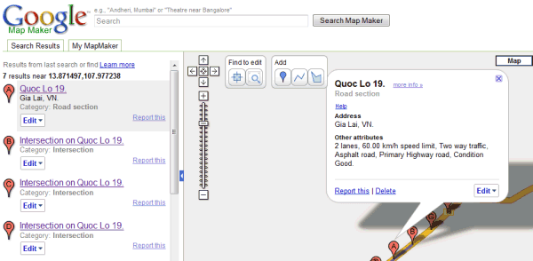
Google Map Maker
Google unveiled Google Map Maker, a product that allows users to contribute and edit map data for regions around the world. More from Lat Long Blog, CNet, GOS
12. juuni 2008

5. juuni 2008
Outdoors touch-screen webmap
An interactive touch-screen webmap that is placed outdoors and connects to internet wirelessly, but not an iPhone.
Põlvamaa talurahvamuuseum (an open air museum reminding how peasants lived in old times) gets an infokiosk with Regio's webmap. The map based on our KOV project will serve useful information about places to visit around the museum to tourists visiting museums info-center.

Info-kiosk hardware was provided by ERD Estonia OÜ
29. mai 2008
Google Earth Plug-in Puts Google Earth in Your Browser
Windows only: The freeware Google Earth plug-in integrates Google Earth with your web browser, embedding the 3-D glory of Earth in Firefox or Internet Explorer. The results, which you can see in the video above, are impressive. There isn't a ton of Google Earth plug-in integration on the web yet, but check out the samples to understand the possibilities, like switching between Google Maps and Earth on-the-fly. The Google Earth plug-in is Windows only, supports Firefox and Internet Explorer.
Tellimine:
Postitused (Atom)