For more than a year there’s been no posts to Webmap blog from our team and there will be no one. We’ve been moved into new location at BLOG.REGIO.EE/APPS. It is our new home now wherein you can find a track list of GIS applications made by our team (access to some of them can be limited).
Welcome!
7. mai 2010

13. apr 2009
New web-map API services covering Baltics
We are proud to announce new WMS services and API-s:
Map in WMS standard with layer control. (Coverage: Baltic, Estonia, Latvia, Lithuania)
Ortophoto (Est. Latvia in progress)
Geocoding API with XML/JSON output.
(Baltic, Est, Lat, Lit)
Reverse-geocoding API with XML/JSON output.
(Baltic, Est, Lat, Lit)
Routing API between multiple points with XML output.
(Est, Lat, Lit. Baltic's in progress).
See level of map details at regio.delfi.ee and maps.delfi.lt For more information about API-s contact us.

Map in WMS standard with layer control. (Coverage: Baltic, Estonia, Latvia, Lithuania)
Ortophoto (Est. Latvia in progress)
Geocoding API with XML/JSON output.
(Baltic, Est, Lat, Lit)
Reverse-geocoding API with XML/JSON output.
(Baltic, Est, Lat, Lit)
Routing API between multiple points with XML output.
(Est, Lat, Lit. Baltic's in progress).
See level of map details at regio.delfi.ee and maps.delfi.lt For more information about API-s contact us.
17. okt 2008
Physics with icons
Making maps closer to real world has been in maps-makers scope for long time. What about borrowing idea of physics-law-like behaviors to web-maps form BumpTop desktop interface? It turns your desktop into a 3D space and lets you move your documents the way you would on a physical desktop.
1. okt 2008
Flash player for the iPhone?
Adobe is actively developing a Flash player for the iPhone— now all they're waiting for is the OK from Apple.
Apple may have many reasons for not allowing Flash onto the iPhone, but if anyone has a good shot at getting their technology into the device, it would be Adobe.
More from: Flashmagazine
Apple may have many reasons for not allowing Flash onto the iPhone, but if anyone has a good shot at getting their technology into the device, it would be Adobe.
More from: Flashmagazine
27. aug 2008
ArcGIS server Flex API
ESRI announced the new ArcGIS API for Flex Beta at the ESRI International User Conference in San Diego, California, which was held August 4–8, 2008. Read more at DM press release...
First look and feel is quite good, but it's really still a beta ;-)
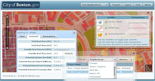
Also listen to the podcast at the same topic.
First look and feel is quite good, but it's really still a beta ;-)
Also listen to the podcast at the same topic.
1. juuli 2008
Interactive tourism-map (KOV)
There is new map on our products line. Interactive tourism-map (oftentimes called KOV inside Regio) is a tool for local municipalities, tourism portals etc to promote POI-s, hiking-routes, nature parks etc on map. It has features like route calculation, intelligent address-search, multible map views, emailing and printing map.
Even more noteworthy are its administration possibilities: Administrator can customize whole map interface design, its measures, and behaviour of objects, depth of zoom levels etc. Of course, has total control over object (also upload pictures to POI-s), layer and groups management.

Try our public demo account:
Map: http://teenus.regio.ee/kov/index.php?id=199
Admin: http://teenus.regio.ee/kov/admin
User: „demo“
Pass: „demo123“
NB! User rights in demo are limited.
Examples of projects using KOV:
- Map of MTÜ Pandivere Arendus-ja Inkubatsioonikeskus
- Map of Põlvamaa talurahvamuuseum. More about this project
- With interface using special design.
Even more noteworthy are its administration possibilities: Administrator can customize whole map interface design, its measures, and behaviour of objects, depth of zoom levels etc. Of course, has total control over object (also upload pictures to POI-s), layer and groups management.
Try our public demo account:
Map: http://teenus.regio.ee/kov/index.php?id=199
Admin: http://teenus.regio.ee/kov/admin
User: „demo“
Pass: „demo123“
NB! User rights in demo are limited.
Examples of projects using KOV:
- Map of MTÜ Pandivere Arendus-ja Inkubatsioonikeskus
- Map of Põlvamaa talurahvamuuseum. More about this project
- With interface using special design.
Baltic maps

Mapsite for kids
New map application for the Estonian most popular kids' website Lastekas.ee is live. Introducing innovations like typing in capital letters, interface and POI-s with sound assistance and special design, it is one of few online maps designed specially for children. Try it here.


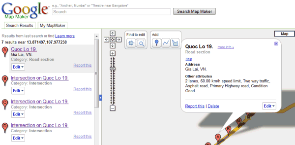
Google Map Maker
Google unveiled Google Map Maker, a product that allows users to contribute and edit map data for regions around the world. More from Lat Long Blog, CNet, GOS
12. juuni 2008

5. juuni 2008
Outdoors touch-screen webmap
An interactive touch-screen webmap that is placed outdoors and connects to internet wirelessly, but not an iPhone.
Põlvamaa talurahvamuuseum (an open air museum reminding how peasants lived in old times) gets an infokiosk with Regio's webmap. The map based on our KOV project will serve useful information about places to visit around the museum to tourists visiting museums info-center.

Info-kiosk hardware was provided by ERD Estonia OÜ
Põlvamaa talurahvamuuseum (an open air museum reminding how peasants lived in old times) gets an infokiosk with Regio's webmap. The map based on our KOV project will serve useful information about places to visit around the museum to tourists visiting museums info-center.

Info-kiosk hardware was provided by ERD Estonia OÜ
29. mai 2008
Google Earth Plug-in Puts Google Earth in Your Browser
Windows only: The freeware Google Earth plug-in integrates Google Earth with your web browser, embedding the 3-D glory of Earth in Firefox or Internet Explorer. The results, which you can see in the video above, are impressive. There isn't a ton of Google Earth plug-in integration on the web yet, but check out the samples to understand the possibilities, like switching between Google Maps and Earth on-the-fly. The Google Earth plug-in is Windows only, supports Firefox and Internet Explorer.
15. mai 2008
Wikipedia Added to Google Maps
In what is proving to be another busy day for Google, Wikipedia articles have been added to Google Maps. The new Wikipedia tags can be turned on via a 'More' button that has been added to the top right hand corner of the map.
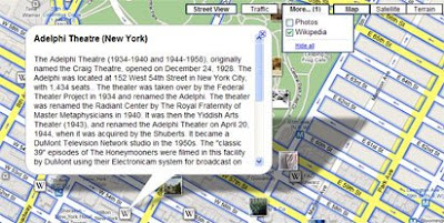
When the Wikipedia tick box is selected small 'W' tags appear on the map where Wikipedia articles are available. Clicking on the 'W' tag will open an information window containing the Wikipedia article.
Panoramio photos can also be turned on via the same 'More' button. The photos option however feels a little superfluous considering Panoramio photos were added last week and can also be turned on in the left-hand panel. Intriguingly the photos turned on by the 'More' button contain a Panoramio logo whilst the ones accessed by the left-hand side panel don't, even though both sets of photos are served by Panoramio.
Via Googlemapsmania
When the Wikipedia tick box is selected small 'W' tags appear on the map where Wikipedia articles are available. Clicking on the 'W' tag will open an information window containing the Wikipedia article.
Panoramio photos can also be turned on via the same 'More' button. The photos option however feels a little superfluous considering Panoramio photos were added last week and can also be turned on in the left-hand panel. Intriguingly the photos turned on by the 'More' button contain a Panoramio logo whilst the ones accessed by the left-hand side panel don't, even though both sets of photos are served by Panoramio.
Via Googlemapsmania
6. mai 2008
Mapping orienteering routes
RouteGadget is web utility for drawing and comparing orienteering routes. It is Java applet running on browser and Perl scripts running on server that can be installed on any Unix, Linux, Windows server or used locally on PC / laptop. Free, no quarantees, support etc. Made by volunteer :-)
Hansapank Xdream demo:
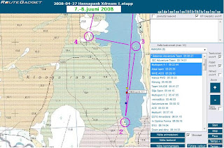
Hansapank Xdream demo:
Digitizing on Openlayers
Digitizing on Openlayers and many other useful developers hints including GML, KML parsers etc:
- http://www.openlayers.org/dev/examples/modify-feature.html
- http://www.openlayers.org/dev/examples/
- http://www.openlayers.org/dev/examples/modify-feature.html
- http://www.openlayers.org/dev/examples/
28. apr 2008
Easy way to GIS
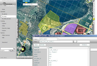
This "Easy Way to GIS" seems to be our MapCat PRO competitor: there's less flexibility for IT integrators etc but much more GUI (ready product, "MI Professional" in web). See also GDSK Geoplatform Introduction (PDF)
21. apr 2008
Whereyougonnabe
Whereyougonnabe application has now gone live, Facebook account users can try it out here. Read more information about the application at our founder Peter Batty's blog (announcement and review).
Whereyougonnabe is a service which enables you to geocode and save locations where and when you will be doing things in the future (where you gonna be?), also you can see when your friends will be close to you. You can view information on Google maps in both in a browser and using Google Earth.
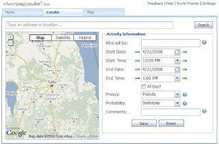
Whereyougonnabe is a service which enables you to geocode and save locations where and when you will be doing things in the future (where you gonna be?), also you can see when your friends will be close to you. You can view information on Google maps in both in a browser and using Google Earth.
18. apr 2008
GIS microsite of Regio
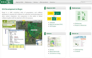
Now information about our products, services, demos, references etc also available through GIS microsite at www.regio.ee/gis.
...and demos directly:
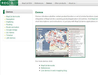
...and demos directly:


16. apr 2008
Google Earth gets next major update
The Google Earth Blog has produced video highlighting some of the newly added features like streetview, day/night lighting effects, faster loading 3d buildings and more in Google Earth 4.3. 
Tellimine:
Postitused (Atom)