
20. dets 2007
Joystick again
Joystick may give quite good control over map moving or pan: direction, extent and speed. Try MyMiniCity navigation and see also previous post at the same topic here...
19. nov 2007
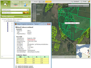
Estonian Forest Registry in web
Estonian Forest Registry is finally accessible through web. New and attractive web-site will be released soon in cooperation with Regio webmap team (us :-) and Centre of Forest Protection and Silviculture.
8. nov 2007
New era in MapCat development
Map application for biggest internet portal in Baltics (Delfi) that brings us to new era is finally ready:
- try new drag'n'drop layer menu: order of layers is saved in cookies so you can personalize your menu, also the sequence of displaying symbols on top of the map is influenced by layers order.
- animated zoom: map is moving towards search results visualizing the access to an address, location or route.
- map navigation by using keyboard: pan, zoom in and out using just 'arrow' keys.
- search options and driving guidance: show all results as a list or use map bbox for filtering results; show all search-list items or line segments on the map and highlight them both on map or search-list.
- draw your own map and send it to your friend or save in your blog, web-site etc.
- ...and many-many more!
Application for Delfi is first customer project implemented by using technology developed within R&D project named GISSER funded by Enterprise Estonia.
6. nov 2007
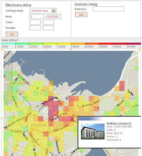
KV real-estate chorophlet map
Estonian real-estate portal KV launched their new map search based on our MapCat Medium component. When choosing a deal type and parameters like price, number of rooms etc, map will be covered with vector layers of average m² price and property objects corresponding to the search preconditions. Useful tool for finding property via map.
2. nov 2007
Move Mis-Marked Addresses in Google Maps
Ever look up an address on Google Maps and find that the pushpin for that address is more than a bit off? Now you can edit where Google pinpoints addresses (provided you're logged into your Google account) by clicking the Edit link and dragging the pin to a more appropriate location.
Via LifeHacker
Via LifeHacker
24. okt 2007
Cool idea for real-estate portals
Great idea that is possible to gain easily through our MapCat API either :-)

9. okt 2007
Some cool web-maps
Cairolocator - Interactive web mapping solution covers Cairo with detailed maps .It allows users to search in more than 5000 pos and streets.cairolocator is the first web map application supports Arabic.
FlashNavigator - Demonstration of flashNavigator technology. Using powerful Flash map engine flashNavigator is able to display GIS and CAD file formats in Flash viewer. This world map was created using ESRI Shapefile source. Map is divided into 7 layers and it can be fast panned and zoomed. Also there is statistical GIS analysis available. Map is colored in real time to display results of analysis. There is an option to test your own SQL queries and see results on map.
DynaWebMap - DynaWebMap provides a powerful server side map web control which integrates with gViewTek's vector maps library. Users can select their own interesting maps and connect their own data, such as demographic data or other statistics data through data binding fields. DynaWebMap map web control provides wonderful vector map with professional map operations and dockable map components, such as toolbars, overview map, dynamic legend, and charts. DynaWebMap allows users and developers to easily create, display the dynamic web-based vector map, and chart through a group of simple code inside the web pages or behind the web pages.
More from Directions Magazine's web map gallery
2. okt 2007
New GUI for tourism applications
As a result of GISSER (one of our R&D projects funded by Enterprise Estonia) new release of our tourism map-applications will be launched next week. First customer using upgraded technology and advanced GUI will be the biggest Estonian internet portal Delfi (see application under construction here).
Application is built based MapCat technology and attractive GUI for tourism-like type of applications is designed in cooperation with Webmedia design division. Long-term objective of this cooperation was to elaborate GUI traits characteristic to all our webmap applications including MapCat API.

Application is built based MapCat technology and attractive GUI for tourism-like type of applications is designed in cooperation with Webmedia design division. Long-term objective of this cooperation was to elaborate GUI traits characteristic to all our webmap applications including MapCat API.
26. sept 2007
Newsletter about ASP services and data updates
We started to send newsletter to our customers (only in estonian). Main motivator of doing this was need for updated information about our services and data updates, but also software upgrades and latest customer projects.
Regio runs biggest masperver in Baltics and more than 100 applications are using our ASP services daily. See newsletter archive in blog and also latest release about map updates here
Regio runs biggest masperver in Baltics and more than 100 applications are using our ASP services daily. See newsletter archive in blog and also latest release about map updates here
17. sept 2007
From Google Maps directly to your Mercedes Benz
Mercedes-Benz has recently included a Google Maps service for drivers called Search & Send. The service will give Mercedes-Benz drivers who are equipped with Tele Aid the ability to send destinations and searches directly from Google Maps. More from Google Maps Mania blog...
13. sept 2007
Merge Your Map on Yahoo Maps with MapMixer
Yahoo launches new webapp MapMixer, which blends an existing map image with Yahoo Maps. Handy for overlaying a static public transportation system, campus or hiking trails map onto a fancy-pants dynamic Ajax map, MapMixer's essentially an easy-peasy mashup maker for anyone with a map digital image (or a scanner). Just upload your image and fit it onto Yahoo Maps.

Check out some more MapMixer creations in the featured map gallery.
7. sept 2007
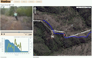
Video playpack syncronised on map
VeoGeo is a community based mashup using user GPS data, user video from YouTube and Google maps to playback video in sync with GPS data on Google map.
The mashup is still in early Beta, but working with existing examples very well.
This kind of mashups may have a lot of potential in tourism industry and others, especially when cellphones will have good GPS (A-GPS) support.
veogeo.com
The mashup is still in early Beta, but working with existing examples very well.
This kind of mashups may have a lot of potential in tourism industry and others, especially when cellphones will have good GPS (A-GPS) support.
veogeo.com

17. aug 2007
JavaScript Map API comparison
Look at comparison of performance and developer friendliness of JavaScript mapping APIs by Niall Kennedy here...
See also Mapstraction.com website (library that provides a common API for various javascript mapping APIs to enable switching from one to another) and demos.

13. juuli 2007
Papervision3D Public Beta
Papervision is 3D engine released under the MIT Open Source litsense:
...It started as a simple way to transform MovieClips to achieve the 3D illusion. By changing their position, size, rotation and skew you could almost forgive the lack of perspective. But the latest version, fully optimised for Flash 8 Image API, uses triangle tesselation to distort textures. Now we can render complex objects in “real 3D”!

Read also Adobe's article" Mapping Flash video to 3D objects".
...It started as a simple way to transform MovieClips to achieve the 3D illusion. By changing their position, size, rotation and skew you could almost forgive the lack of perspective. But the latest version, fully optimised for Flash 8 Image API, uses triangle tesselation to distort textures. Now we can render complex objects in “real 3D”!
Read also Adobe's article" Mapping Flash video to 3D objects".
12. juuli 2007
Nutimap beta
Now you can download and test Nutimap interactive mobile map application. It has Regio detailed maps and address data, MGMaps.com application.
It supports:
- Regio most detailed Estonian maps (up to house number level)
- Search for addresses and placenames in Estonia (also up to house numbers)
Other key features:
- Track your location using GPS (via Bluetooth)
- Save your favourite locations
To be done yet:
- Search objects (POI) around some place
- Route directions
- million other extension ideas...
3. juuli 2007
Routing on the fly
29. juuni 2007
Cooperation of Microsoft and Maporama
Microsoft’s Virtual Earth mapping platform featuring roadmaps, satellite and aerial imagery, plus bird’s eye and 3-D views will be available for Maporama Intl corporate customers. They will benefit from increasingly innovative and complete solutions to meet their business needs: geolocalization, business intelligence, geomarketing, and mobility. Read the press release...

25. juuni 2007
Flex for ESRI?
Whereas we've combined Adobe Flash + AJAX technology and Minnesota server components to create rich internet applications (RIA's) many years for today, Esri has started partnership to develop their new generation platform also:
...Universal Mind Inc. today announced it will team with ESRI and Adobe to create a new generation of rich Internet applications that leverage ESRI’s enterprise GIS platform and Adobe® Flex™ software to make geographic analysis and access easy and ubiquitous. Read more (DM 22.06.2007)...
See also Google Maps travel and exploration mashup Geowalk with new UI made with Adobe Flex 3(See previous version of GeoWalk). More from Googlemapsmania

21. juuni 2007
Is it allowed?
Many customers have asked, is it possible to use Google free API for applications like SeeMe launched lately. The answer is: NO, IT'S NOT ALLOWED! License says: "Except where you have been specifically licensed to do so by Google, you may not use Google Maps with any products, systems, or applications installed or otherwise connected to or in communication with vehicles, capable of vehicle navigation, positioning, dispatch, real time route guidance, fleet management or similar applications".
See also additional terms of Google API:
…Service may not be used: (a) for or with real time route guidance (including without limitation, turn-by-turn route guidance and other routing that is enabled through the use of a sensor), or (b) for, or in connection with, any systems or functions for automatic or autonomous control of vehicle behavior.
First application from our competitor in paper maps market
We have waited for years when the day comes our competitor in paper maps market starts to serve internet maps and build webmap applications. The day has come!
True, the first application is rather example of how a map application should not be built on 21th century. It's good illustration of architecture we tried to avoid starting development of MapCat SDK years ago (use together with LiveHTTPheaders sidebar). Still, it works somehow regardless some serious usability issues and probably next version will already be better. Potential competitor in Estonian market for some years and I hope it makes us stronger also :-) Worth to be blogged!

True, the first application is rather example of how a map application should not be built on 21th century. It's good illustration of architecture we tried to avoid starting development of MapCat SDK years ago (use together with LiveHTTPheaders sidebar). Still, it works somehow regardless some serious usability issues and probably next version will already be better. Potential competitor in Estonian market for some years and I hope it makes us stronger also :-) Worth to be blogged!
1. juuni 2007

24. mai 2007

Future of routing services?
Movin 360 Berlin tour recalls a city journey on a map and a 360 degree panorama- video. Camera viewpoint can be changed on video screen.
The development of map.movin360 is thesis (diploma) work of Christian Müllenhagen and Fabian Zastrow during wintersemester 2006/2007 at Technischen Fachhochschule Berlin. More in German...
The development of map.movin360 is thesis (diploma) work of Christian Müllenhagen and Fabian Zastrow during wintersemester 2006/2007 at Technischen Fachhochschule Berlin. More in German...
23. mai 2007
Yahoo maps: new design, new engine
Cartifact announced that their map design work is prominently featured in the recently released version of Yahoo! Maps worldwide. The goal of the project was to create a style distinct from other web maps, in both visual appeal and content. Yahoo! officially launched the new map styles on May 16.
Also it seems Yahoo has given up of using DeCarta map engine...
Also it seems Yahoo has given up of using DeCarta map engine...
18. mai 2007
Search from radius
Quite fancy solution of map UI for typical problem of search from radius. Based on google maps, but that's besides the point.
http://www.properazzi.com/
http://www.properazzi.com/
16. mai 2007
28. apr 2007
Chat, pictures, locate friends
Some nice ideas how to build GUI for FriendFinder and make map more attractive and interactive:
...RadiusIM combines IM with location. It’s the only site that shows you where your friends are hanging out and lets you surf for other people based on location. It supports all the major networks: MSN, AIM/ICQ, Yahoo, and GTalk/Jabber. And you can use radiusIM from anywhere because there are no downloads.

See also another idea how to make website more flexible and customizable here and ideas for implementation here.
...RadiusIM combines IM with location. It’s the only site that shows you where your friends are hanging out and lets you surf for other people based on location. It supports all the major networks: MSN, AIM/ICQ, Yahoo, and GTalk/Jabber. And you can use radiusIM from anywhere because there are no downloads.
See also another idea how to make website more flexible and customizable here and ideas for implementation here.
26. apr 2007
Google Maps update in Baltic States
 Google Maps has made a major update on Estonian and Lithuanian map data. Road and railway networks, forest areas, water bodies, place names and urban areas have been updated all over the countries. On all major cities are now street networks with name labels and directions that makes possible road navigation. Also green areas with names have been added to the map in those cities.
The data is claimed to be provided by TeleAtlas. Data seems to be two, three years old (e.g. Raadimõisa).
In Latvia only Riga seems to be updated with street level and railway data.
Still, at the moment, the update doesn't expand to maps created with Google Maps API so you can use it only on http://maps.google.com.
Also it's quite interesting that Google Maps has started to publish some aerial images with super zoom levels (by default zoom bar allows maximum zoom level 13, but some areas have now up to 23). Question of privacy? Google has been using also their own planes for aerial images.
23. apr 2007
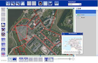
Thematic map for QVIZ
This is our first prototype for QVIZ - map application capable of drawing thematic maps about time-spatial distribution of digitized historical documents. Polygon color refers to amount of items (historical resources) within search result. Developers can use map as a search filter/faceted query component (specify search by map parameters: bounding box, selected ploygon etc).

21. apr 2007
Animation examples
Some sexy examples about animation:
http://www.alexisparkinn.com/photogallery/Videos/2006-5-5_FedExDiversions.wmv
http://www.alexisparkinn.com/photogallery/Videos/2006-10-21-FAA-just-plots].mov
http://www.alexisparkinn.com/photogallery/Videos/2006-10-21-FAA-sees-USA.mov
http://www.alexisparkinn.com/photogallery/Videos/2006-5-5_FedEx_25HR_OPS.wmv
12. apr 2007
Google maps mashups
Google maps real-time tracking
Helsinki public transport mashup takes the locations of buses and trams in the Helsinki City transport network and plots their real-time location to a Google Map for you to watch, live!

Click on the vehicle and and the info-window gives you the option to show the route this it's traveling, plot the stops and also center the map on that bus/tram as it makes its way around the city. Watch the times to each stop as well. It's an invaluable tool to Helsinkians or tourists, as well as fun and addictive to watch for the rest of us! Very nicely done! [Via GoogleMapsMania]
Google Mapplets: Mashups Of Mashups
Trulia Hindsight
Helsinki public transport mashup takes the locations of buses and trams in the Helsinki City transport network and plots their real-time location to a Google Map for you to watch, live!
Click on the vehicle and and the info-window gives you the option to show the route this it's traveling, plot the stops and also center the map on that bus/tram as it makes its way around the city. Watch the times to each stop as well. It's an invaluable tool to Helsinkians or tourists, as well as fun and addictive to watch for the rest of us! Very nicely done! [Via GoogleMapsMania]
Google Mapplets: Mashups Of Mashups
A new feature in Google Maps, Mapplets, places data overlays onto your map - like movie times, crime rates and real estate prices. Mapplets just makes different mashups available on Google Maps proper, instead of having to go to another site to see them.
Trulia Hindsight
Trulia Hindsight is an animated map of homes in the United States from Trulia. The animations use the year the properties were built to show the growth of streets, neighborhoods and cities over time. View the map »
Google Maps Street View
Google launched a new feature for Google Maps that will include a street-level view. Good way to make street level maps useful as well as impressive to look at.
It's cool to virtually drive down the street,to search for driving directions, and then actually see the route before getting in the car. See also Google Maps Street View promotional video:
Windows Live Street View literally puts in in the drivers seat — though you have to admit it’s kinda crappy and appears to have been abandoned.
11. apr 2007
FF designed by Art School
Yesterday we had opportunity to have a closer look at concepts and designs of GUI-s from Art School students for our product named Friendfinder. To be honest, presentation of ideas and implementation was something we even couldn't expect, otherwords impressive!

New prototype for friendfinder is part of R&D project with acronym GISSER (GIS Server for Animation) funded by Enterprise Estonia. Read more...
New prototype for friendfinder is part of R&D project with acronym GISSER (GIS Server for Animation) funded by Enterprise Estonia. Read more...
Sharing Data Visualization
IBM is showing that there's more to the social Internet than just sharing pictures and video clips. The company has launched a new website, called Many Eyes, with the hope of adding a social aspect to data visualizations like maps, network diagrams, and scatter plots. Already the site is being used by everyone from Bible researchers to college professors. Read more...
Many Eyes visualization gallery
Selection of Technology Review

Many Eyes visualization gallery
Selection of Technology Review
10. apr 2007
Tourist Guide by SITO
Simple application with quite good usability: anyone doesn't like it but everyone can use ;-)
http://www.liikuntapaikat.fi/
http://kartta.liikuntapaikat.fi/Default.aspx
http://www.liikuntapaikat.fi/
http://kartta.liikuntapaikat.fi/Default.aspx
6. apr 2007
GM My Maps
My Maps allows users to mark locations on a map from a library of icons, draw lines and (note) SHAPES to highlight paths and areas, and add text, photos, or YouTube/Google videos. Users can also add HTML to their maps.
Read more from article at InternetNews.
My Maps is enabled only for users logged in using their gmail account (click on the picture)
Trippish.com
Trippish is a free service that gives you driving directions with weather forecasts along the route. Trippish not only tells you what the weather is likely to be during your drive, but also allows you to determine the best time to leave based on current forecasts.
Implemented by using MS Virtual Earth API.

Implemented by using MS Virtual Earth API.
James Fee GIS blog
Something worth of attention, man from our planet :-)

Blogging GIS, ESRI, Google Earth, Virtual Earth and Programming
Some interesting stuff at first glance:
Esri and flash see also Esri flash client components for ArcIMS here
Map Compare
Neeme sent us comparison of applications side by side last week, I put this into our blog as well:
- Google Maps
- MS Virtual Earth
- Yahoo maps
Map Compare allows you to evaulate which mapping technologies is best. All three maps are locked together so panning, zooming and changing map types will effect all maps the same. You can also use the tab pane to try out various map features like; markers, popups as well.
4. apr 2007
Google ignores Katrina :-)
3. apr 2007
Steel exactly and copy with proud :-)
Tanel found interesting test pages for GM API.

...and others.
Find out how people try to solve similar problems as we from our roadmap and have tried to find some solutions we have solved years ago :-)
Many markers try with 200 or 2000 markers :-)
Overview map idea
Polyline test using SVG

...and others.
2. apr 2007
Base maps
We use our web-mapping technology as core GIS component inside Regio/Reach-U AVL and LBS solutions that is sold worldwide through Ericsson channels. Full set of solution consists of applications, GIS engine, integration work and maps including data management work.
Some examples of base maps:
Map of Saudi-Arabia and new zoom-bar
Estonian maps within Visitestonia.com map application
Latvia (street level maps it towns 1:10.000, base map 1:50.000, ca. 315. 000 address points)
Europe general (1:500.0000)
Ukraine
Marocco
Mexico
Portugal
Some examples of base maps:
Map of Saudi-Arabia and new zoom-bar
Estonian maps within Visitestonia.com map application
Latvia (street level maps it towns 1:10.000, base map 1:50.000, ca. 315. 000 address points)
Europe general (1:500.0000)
Ukraine
Marocco
Mexico
Portugal
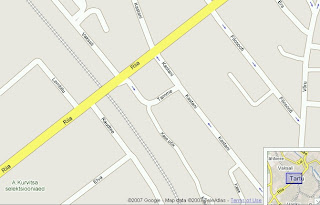
Joystick for map navigation
Interesting sample of interactive mapping application created for Wilhelm Farby Museum in Germany. It is a cool tourism map with an alternative approach to features like:
- map navigation through a joystick;

- several bird's-eye views;
- 360 degrees views of some POI's (also vertical axis);
- image gallery in info- window;
- original ruler and area tools;
Another app with atypical realization is Geowalk combining Flash menus and AJAX maps.
- map navigation through a joystick;

- several bird's-eye views;
- 360 degrees views of some POI's (also vertical axis);
- image gallery in info- window;
- original ruler and area tools;
Another app with atypical realization is Geowalk combining Flash menus and AJAX maps.
1. apr 2007
30. märts 2007

Flash usage and statistics
Statistics of usage of flash player versions:
http://www.adobe.com/products/player_census/flashplayer/version_penetration.html
http://www.adobe.com/products/player_census/flashplayer/
29. märts 2007
Navigation maps for mobile devices
JKL tested some available solutions of GPS/map navigation for mobile devices (smartphone, PDA), here are the results (in estonian)
27. märts 2007
Google Mashups
Some interesting Google mashups:
Detail plannings on the GM;
Panoramio- Million geolocated photos at Panoramio (article);
Who is leader in worlwide online mapping (article);
Global climate map;
MapDotNet;
Detail plannings on the GM;
Panoramio- Million geolocated photos at Panoramio (article);
Who is leader in worlwide online mapping (article);
Global climate map;
MapDotNet;
I like this GUI
First example we're all acquaintent with (Atlas from Fresh Logic Studios), updated lately: Also something new - Reuters interactive map of emergencies Alertnet (beta), some interesting features, architecture etc (made using flash).
Also something new - Reuters interactive map of emergencies Alertnet (beta), some interesting features, architecture etc (made using flash). Something to keep in mind regarding our FT nad TG development :-)
26. märts 2007
Flash Inspiration
Collection of flash-maps that inspired us while starting flash-development.
Flashearth and mr Neave development works at neave.com, idea for FlashTile:
 US Flashmaps using maps with high vector graphics
Flashearth and mr Neave development works at neave.com, idea for FlashTile:
 US Flashmaps using maps with high vector graphics
Carto Net collection of flash-maps, flash vs SVG
Geoclip thematic maps QVIS R&D, also UI-s at large
Zillertal Ski panoramas, idea for our so-called "rastersolution"
Zillertal Ski animations
Geoclip thematic maps QVIS R&D, also UI-s at large
Zillertal Ski panoramas, idea for our so-called "rastersolution"
Zillertal Ski animations
23. märts 2007
Standard for tiling
Open Source Geospatioal Foundation has initiated some work to standardize raster tiling technology as technology for back-drop maps in map applications. Read more...
22. märts 2007
MC FlashTile demo site
FT javascript API demo-site:
http://kaardid.regio.ee/demo/FlashTile/edit/
New version of zoombar (first feature implemented by Jevgeni):
http://www2.regio.ee/ftdemo/
Zoom to mouse pointer while scrolling the mouse
http://www.eoy.ee/atlas/upgrade/indexeng.php
http://kaardid.regio.ee/demo/FlashTile/edit/
New version of zoombar (first feature implemented by Jevgeni):
http://www2.regio.ee/ftdemo/
Zoom to mouse pointer while scrolling the mouse
http://www.eoy.ee/atlas/upgrade/indexeng.php
21. märts 2007
Flex on Google Maps
Google Maps Collaboration using Flex, Flash Media Server and Ajax (Updated for Flex 2 GA)
Interesting tool wherein some nice features have been implemented from our roadap:
Interesting tool wherein some nice features have been implemented from our roadap:
- Map sharing: Maps are kept in sync (in real time) between users involved in a collaboration session.
- Videoconferencing (Webcam sharing and VOIP): You can share your Webcam and microphone to add video and audio to your collaboration session.
- Whiteboarding: Collaborating users can draw on the map. For example you could draw potential directions, etc. The users’ whiteboards are kept in sync in real time.
- Cursor sharing: When you move your mouse, other users see the movements of your mouse and what you are pointing at.
Look at the demo here (username 'quest' worked well)
Adobe Apollo - new approach to internet maps?
Apollo offers tools for offline applications created using HTML, AJAX ja Flash:
Apollo is a cross-operating system runtime that allows you to install desktop applications that are built using web technologies like HTML, JavaScript, and Flash. The technology allows rich Internet applications to run offline, and could threaten the popularity of programming platforms such as Java and Microsoft .NET, Adobe has said.
PC- World and Adobe Labs articles plus videodemo.
17. märts 2007
Yell kaardirakendus
http://www.yell.com kaardirakendus. Huvitavalt on lahendtud kaardi nn. hübriidvaade, kus kuvatakse põhimaanteed, -tänavad ja jõed ainult kursori "kasti" sees. Aerial ja Hybrid vaate puhul muutub ka zuumbar lühemaks.
Midagi toredat ka e. kuidas tilesid kopeerida- Vajuta kaardiaknas Ctrl+A ja tee Paste näiteks Wordi dokki.
Midagi toredat ka e. kuidas tilesid kopeerida- Vajuta kaardiaknas Ctrl+A ja tee Paste näiteks Wordi dokki.
16. märts 2007
Selection of tourism maps
Visitestonia Tourism Agency of Estonia (initial version of new solution), old version here
Map of Tallinn tourism, transportation, trip planner etc
Delfi mapsite address search, ATMs, Gas stations, Internet
Tourism web
Tourism application for municipalities
Estonian Post post offices and letter boxes on the map
Viljandi city map for tourists
Tallinn public transport (old)
Tallinn tourismweb
Via Baltica
Statoil gas stations
FlashTile for Affecto
Good news! Finnish leading GIS company Affecto (former AffectoGenimap) started using our flashtile technology. First projects will be implemented based on MC Light and Medium.
First customer project in live:
http://www.gva.fi/gva/Main.do
...and demo from development process here
First customer project in live:
http://www.gva.fi/gva/Main.do
...and demo from development process here
15. märts 2007
R&D activities
To sustain the competitive advantage of our products and technology, Reach-U/Regio spends substantial amount of the revenue on R&D.
We participate in number of EU FP6 projects (Motive, Wisecom, QVIZ) and also we’ve got lots of support from Enterprise Estonia foundation to develop new technologies (Gisser, Logisme, others). Our team is responsible for two of them:
GISSER
The aim of GISSER is to work out GIS server of new era and user interfaces for mobile phones and web with high usability and animation support. Animated may be layers on the map and map handling but also the map itself (streaming river). For achieving this aim we cooperate with scientists at many disciplines like psychologists, geographers, computer scientists and design students.
Contact riho@regio.ee for futher discussions (cooperation proposals etc).
QVIZ
The aim of QVIZ is to give better visualization tools for cultural heritage institutions and resources like archives, museums etc. Visualizing time-spatial connections between historical events on the map offer better access tools for scientists as well as for for wider population.
Ask information kalev@regio.ee
Estonian Breeding Bird Atlas
New version of Estonian Breeding Bird Atlas based on MapCat Medium and flashtile technology. Nowadays birdwatch and data collecting is based on 5x5 km UTM squares but as 10x10 had been used before 2003 then follow-up project is planned before 2010 (end of the project). The aim of this project is to make those data comparable (generalization of data collected based on 5x5 will be done). Today only data collected 2003 and later is published.
Direct link to english version here
Direct link to english version here

14. märts 2007
L-Est to WGS and vice versa
An old tool, useful for keeping in mind our future defelopment work, but irreplaceable for GPS users etc already today:
http://kaardid.regio.ee/coords/
http://kaardid.regio.ee/coords/
FlashTile live
LIVE DEMOS
Bird Atlas new version of Bird Atlas based on FlashTile, direct link to english version here
County of Põlva map solution for web-sites of municipalities (public map and admin-tools)
Visitestonia Tourism Agency of Estonia (initial release)
Trees with Christ
Map of manors
Additionally ASP service of Affecto, LBS applications FriendFinder, Childfinder and Monitor, applications for software of logistics AVL, Cargo Monitor.
UNDER CONSTRUCTION
FlashTile demo site for FT javascript API
Bird Atlas 10x10 version for administrator
MonitorMexico our first FlashTile demo having animation (see also tester.regio.ee/mo)
Demo version of municipality-package:
- public site kaart1.regio.ee/demo/pak/
- tool for administrator kaart1.regio.ee/demo/pak/admin
Google links to Maps24
Due to the new cooperation between Google, Inc, and Mapsolute GmbH, maker of the unique mapping portal Map24.com, it is now possible to search for city maps in all European Google search engines. If you enter a city name into Google.co.uk, the first result list entry is a special link to Map24.com that brings up the corresponding city map. On the result page, for sure, the full set of the rich Map24 options is available to the users.
http://www.google.co.uk
London at Maps24
London at Google
London at Michelin
http://www.google.co.uk
London at Maps24
London at Google
London at Michelin
Ask who we are :-)
Riho Plado,
Team leader
+372 7 387 304
riho at regio.ee
Tanel Viin,
Sales and ASP services
+372 7 387 442
tanel at regio.ee
Kalev Koppel,
Software development, R&D activities
+372 387 313
kalev at regio.ee
Team leader
+372 7 387 304
riho at regio.ee
Tanel Viin,
Sales and ASP services
+372 7 387 442
tanel at regio.ee
Kalev Koppel,
Software development, R&D activities
+372 387 313
kalev at regio.ee
12. märts 2007
E-turundusest
Tekkis väike mõttevahetus blogimisest ja e-suhtlusest üldse,
abiks suhtumise kujundamisel mõned Kalevi leitud viited:
E-Turunduse konverentsi ettekanded
http://www.altex.ee/e-turundus-arhiiv
Sealhulgas:
Ajaveebinduse Skype näitel
abiks suhtumise kujundamisel mõned Kalevi leitud viited:
E-Turunduse konverentsi ettekanded
http://www.altex.ee/e-turundus-arhiiv
Sealhulgas:
Ajaveebinduse Skype näitel
MapCat Pro
Demo site for MapCat PRO SDK
Ortophotos of Pärnu have been used as a base map for demo from Regio map server. Editable layers are houses and streets, demo icludes most of client side functionalities exept description of javascript API.
Ortophotos of Pärnu have been used as a base map for demo from Regio map server. Editable layers are houses and streets, demo icludes most of client side functionalities exept description of javascript API.
11. märts 2007
EMT oma andmeuuenduse liides
Kunagi aastaid tagasi tegi Rainer EMT-ile Mynearest baasile on-line andmete uuendamise liidese. See tundub tänini töötavat http://lbs.emt.ee/LBData/ aadressil (kasutajanimi: regio, parooli ei julge siia panna :). Vt põhilehtede screenshotid comments alt, et funktsionaalsusest aimu saada. Liides on eelkõige tekstipõhine, ja kaardile saab detailide juurest vaid vaatamiseks.
Asi oligi mõeldud vanade objektide kustutamiseks ja nimede/kirjelduste parandamiseks, mitte niiväga kaardil uute andmete lisamiseks. Viimane on muide samas võimalik, kuid asukoht käib geokodeerimisega: pärast tekstiandmete (sh aadress) sisestust vajutad nupule "geokodeeri" ja ta annab aadressile automaatselt leitud vasted, millest saab siis õige valida. Ei mingit kaardil zoomimist ega klikkimist.


Asi oligi mõeldud vanade objektide kustutamiseks ja nimede/kirjelduste parandamiseks, mitte niiväga kaardil uute andmete lisamiseks. Viimane on muide samas võimalik, kuid asukoht käib geokodeerimisega: pärast tekstiandmete (sh aadress) sisestust vajutad nupule "geokodeeri" ja ta annab aadressile automaatselt leitud vasted, millest saab siis õige valida. Ei mingit kaardil zoomimist ega klikkimist.


10. märts 2007
VK admin-vahendid (eelajalooline stuff)
http://kaardid.regio.ee/map/mapwindow.phtml demokeskkond kaaripäringu testimiseks
http://kaardid.regio.ee/admin VK kliendi admin-keskkond, statistika
http://kaardid.regio.ee/mmaadmin VK projektijuhi töövahend kasutaja lisamiseks, statistika
Vaja kasutajatunnuseid, mingi ime läbi on need ka täitsa olemas :-)
http://kaardid.regio.ee/admin VK kliendi admin-keskkond, statistika
http://kaardid.regio.ee/mmaadmin VK projektijuhi töövahend kasutaja lisamiseks, statistika
Vaja kasutajatunnuseid, mingi ime läbi on need ka täitsa olemas :-)
GCAdmin e geokodeerimise töövahendid
Unustusehõlmas rakendused
http://kaardid.regio.ee/EestiAadressid/index.php
http://kaardid.regio.ee/latadmin/index.php
Töötav stuff
http://kaardid.regio.ee/gcadmin/
http://kaardid.regio.ee/gcadmin/ergo
http://kaardid.regio.ee/gcadmin/energia
http://tester.regio.ee/tiru/gcadmin_codew/
http://kaardid.regio.ee/kprojekt
Kõik vajavad ligipääsuks U/P (saab VK kuudist vajadusel :)
About us
Regio/Reach-U is leading software company in Baltics with excellent experience in GIS and understanding of GIS related content (maps and GIS databases). We are proud to have global partnership agreement with Ericsson for reselling LBS solutions and middleware worldwide.
Regio/Reach-U has customers for our GIS software products in Estonia, Finland and Sweden, but also in Slovakia, Romania, Marocco, United Arabic Emirates, Saudi-Arabia, India, Mexico, Ukraina. Our main customers are mobile operators worldwide and their clients using our software but also enterprises maintaining different distribution networks (logistics) and different GIS registrars in forestry, fields and military sector.
Our web based GIS software is used by all main internet portals in Baltics and sold as SDK (Software Development Kit) for bigger GIS companies in Finland (Affecto, Tietoenator).
Regio/Reach-U is also partner of Navteq http://www.navteq.com/ regarding collecting and maintaining navigation GIS database for Baltics, data provider for Maporama http://www.maporama.com/ services and Michelin www.michelin.com maps.
Google kasutustingimused
Tanel, plz uuenda seda blogist leitud Google-Yahoo-jt hinnavõrdlusega vendadelt, kes neid kommertseesmärgil kasutavad.
Üldised tingimused:
http://maps.google.com/terms_of_service.html
Google'i teenused on tehtud kättesaadavaks ainult teie isiklikuks ja mitteäriliseks kasutuseks. Te ei tohi kasutada Google'i teenuseid toote või teenuse müümiseks või oma veebisaidile suunduva liikluse suurendamiseks ärilisel eesmärgil, näiteks müügi reklaamiks. Te ei tohi võtta Google'i otsingu tulemusi ning neid ümber kujundada ja kuvada või peegeldada Google'i kodulehte või tulemuste lehekülgi oma veebisaidil. Te ei tohi teha metaotsingut üle Google'i. Kui soovite kasutada Google'i teenuseid ärilisel otstarbel, peate eelnevalt Google'iga sellekohase lepingu sõlmima. Lisateabe saamiseks võtke palun meiega ühendust.
1001 salajast kalastuskohta jmt :-)
http://www.programmableweb.com/api/GoogleMaps/mashups
Ideede leiunurk, milleks kõigeks võivad kasutajad tahta kasutada ka meie kaarte ja API-t.
Ideede leiunurk, milleks kõigeks võivad kasutajad tahta kasutada ka meie kaarte ja API-t.
GeoRSS kasutamise näiteid
What is starting to play in radio right now http://www.yes.com/yesnation.swf
Kunagi ka ErkiS saatsis selle lingi listi http://www.mappedup.com/
Kunagi ka ErkiS saatsis selle lingi listi http://www.mappedup.com/
9. märts 2007
Põnevaid kaardilahendeid maailmast
Pasteerin siia lihtsalt Taneli lingikogust viited, selle leiunurgaga tuleb aga tõsisemalt tegeleda.
Google
Geowiki e Wikimapia
GooglemapsMania sait ja lingikogu
http://tags.lifehacker.com/software/maps/
http://blog.programmableweb.com/category/mapping/
http://radar.oreilly.com/tag/geo
http://www.tinymap.net/ väga äge samas ka lihtne UI objektide lisamiseks etc
http://www.heywhatsthat.com/ kliki nupul show profile ja siis kaardil !
http://www.asciimaps.com/ ka nii saab teha
http://gearthblog.com/blog/archives/2007/03/swiss_alps_jet_fight.html Teedule :)
Yahoo maps http://maps.yahoo.com/beta/#mvt=m&trf=0&lon=24.750309&lat=59.429102&mag=6 Yahoo mapsis on realiseeritud funktioon paremklikiga (drive from- drive to). Muud vidinad- funktisoonid ala drag drop directions jt kohta on flässi animatsioonid: http://maps.yahoo.com/flash/features
GeoURL
Erki leid:
Selline asi siis arendamisel, et asukohti saaks linkida veebibrauserites. Sarnaselt „mailto:” lingiga brauserites hakkaks toiminuma „geo:” link, mis avab sinu lemmikkaardirakenduse ja näitab soovitud asukohta
Näiteks Tallinnasse saaks suunata nii:
geo:59.437782,24.754697
GIS baastarkvara vs vabavara
Jutt Esri võimekusest ja võimetusest internetiGIS vallas, blog kust leiab mõndagi huvitavat:
Are we begining to see a shift away from ESRI Server backend to Open Source solutions?
Vt ka artikkel ArcGis bugidest
Are we begining to see a shift away from ESRI Server backend to Open Source solutions?
Vt ka artikkel ArcGis bugidest
Regio.ee kaardi kasutajate sh pirakasutajate leidmine
Erki soovitus googeldamiseks oli:
http://www.google.ee/search?q=link:http://www.regio.ee/%3Fop%3Dbody%26id%3D24&hl=et&start=10&sa=N
Veel ideid?
http://www.google.ee/search?q=link:http://www.regio.ee/%3Fop%3Dbody%26id%3D24&hl=et&start=10&sa=N
Veel ideid?
Neti.ee kasutusstatistika
http://www.neti.ee/info/top100.html
Kõigume seal 50-60 lainel, teeme ära naistelehele, flirt.ee-le ja TÜ veebisaidile, samas Maaja, ETV ja TV3 käest saame napilt tappa :-)
Kõigume seal 50-60 lainel, teeme ära naistelehele, flirt.ee-le ja TÜ veebisaidile, samas Maaja, ETV ja TV3 käest saame napilt tappa :-)
MapCat Light rakendused EFTA
Eesti Post postkontorite ja postkastide asukohad kaardil
Tallinna veeb sõiduplaneerija, ametiasutused, turism, operatiivinfo
Delfi kaardipaik aadressotsing, tanklad, pangaautomaadid jpm
Regio kodulehe kaart linkimise võimalusega
Telemedia ettevõtete asukohad kaardil, asukohaotsing jms
Infopluss aadressotsing, ettevõtete asukohad kaardil
www.city24, www.kv.ee ja www.4seina.ee kinnisvaraportaalid
Viljandi linna kaart
Naabrivalve kaart
Tallinna transpordikaart (vana)
Tallinna turismikaart
Tallinna jäätmekaart vt jäätmekaart
Knnisvaranet
Rasterlahendid
Via Baltica
Võru linna kaart
Halinga valla kaart
Mäetaguse vald
Märjamaa vald
Tartumaa investeeringute kaart
Hääletusvõistluse kaardirakendus
www.jarva.ee kaardilahendid (kõik omavalitsused)
Eestimaa raster (üldine) ja asulaotsing
Statoili jaamade kaart
Erel kinnisvaraobjektid Tallinna kesklinnas
Linnuatlas
jpm
MapCat Medium rakendused EFTA (enne FT aega :-)
Raplamaa
http://www.raplamv.ee/veebikaart/index2.php?lang=0
http://www.raplamv.ee/veebikaart/index2.php?lang=1 inglise keeles
Karula rahvuspark
http://www.karularahvuspark.ee/wwwmap/index2.php?lang=0
http://www.karularahvuspark.ee/wwwmap/index2.php?lang=1 i.k.
PRIA
http://kaardid.regio.ee/pria/index2.php?lang=0
Koolide kaardirakendus
http://kaardid.regio.ee/koolid/
Kuressaare
http://www.kuressaare.ee/mapcat/index2.php?lang=0
http://www.kuressaare.ee/mapcat/index2.php?lang=1
Keskkonnaministeeriumi BTv rakendus (siit kõik algas)
http://tester.regio.ee/kkmin/index2.php
http://tester.regio.ee/kkmin/liigid/index.php?keel=0
EOY linnuatlas
Linnuatlase veebirakendus on töövahend ornitoloogidele vaatlusruutude vailkuks ning vaatlustulemuste edastamiseks projekti koordinaatorile. Linnuatlase upgrade FlashTile'l
Veebikaardi blogist
Selllesse blogisse kogume näiteid Regio veebikaardi meeskonna poolt tehtud töödest ja huvitavaid lahendusi laiast maailmast. Miks me seda teeme? Sellepärast, et jagada infot meie veebikaardi rakenduste arengute kohta ning tutvustada, mida uut on Google, Yahoo jt. tegijate kaardilahendustes.
Regio VK-tiim
Regio VK-tiim
Tellimine:
Postitused (Atom)