Making maps closer to real world has been in maps-makers scope for long time. What about borrowing idea of physics-law-like behaviors to web-maps form BumpTop desktop interface? It turns your desktop into a 3D space and lets you move your documents the way you would on a physical desktop.
Kuvatud on postitused sildiga What do others do. Kuva kõik postitused
Kuvatud on postitused sildiga What do others do. Kuva kõik postitused
17. okt 2008
1. juuli 2008
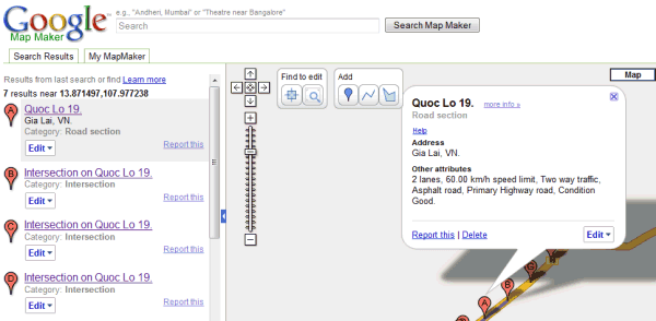
Google Map Maker
Google unveiled Google Map Maker, a product that allows users to contribute and edit map data for regions around the world. More from Lat Long Blog, CNet, GOS
12. juuni 2008

29. mai 2008
Google Earth Plug-in Puts Google Earth in Your Browser
Windows only: The freeware Google Earth plug-in integrates Google Earth with your web browser, embedding the 3-D glory of Earth in Firefox or Internet Explorer. The results, which you can see in the video above, are impressive. There isn't a ton of Google Earth plug-in integration on the web yet, but check out the samples to understand the possibilities, like switching between Google Maps and Earth on-the-fly. The Google Earth plug-in is Windows only, supports Firefox and Internet Explorer.
15. mai 2008
Wikipedia Added to Google Maps
In what is proving to be another busy day for Google, Wikipedia articles have been added to Google Maps. The new Wikipedia tags can be turned on via a 'More' button that has been added to the top right hand corner of the map.

When the Wikipedia tick box is selected small 'W' tags appear on the map where Wikipedia articles are available. Clicking on the 'W' tag will open an information window containing the Wikipedia article.
Panoramio photos can also be turned on via the same 'More' button. The photos option however feels a little superfluous considering Panoramio photos were added last week and can also be turned on in the left-hand panel. Intriguingly the photos turned on by the 'More' button contain a Panoramio logo whilst the ones accessed by the left-hand side panel don't, even though both sets of photos are served by Panoramio.
Via Googlemapsmania
6. mai 2008
Mapping orienteering routes
RouteGadget is web utility for drawing and comparing orienteering routes. It is Java applet running on browser and Perl scripts running on server that can be installed on any Unix, Linux, Windows server or used locally on PC / laptop. Free, no quarantees, support etc. Made by volunteer :-)
Hansapank Xdream demo:
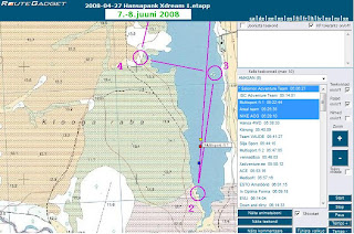
Hansapank Xdream demo:
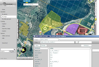
Digitizing on Openlayers
Digitizing on Openlayers and many other useful developers hints including GML, KML parsers etc:
- http://www.openlayers.org/dev/examples/modify-feature.html
- http://www.openlayers.org/dev/examples/
- http://www.openlayers.org/dev/examples/modify-feature.html
- http://www.openlayers.org/dev/examples/
28. apr 2008
Easy way to GIS
This "Easy Way to GIS" seems to be our MapCat PRO competitor: there's less flexibility for IT integrators etc but much more GUI (ready product, "MI Professional" in web). See also GDSK Geoplatform Introduction (PDF)
16. apr 2008
Google Earth gets next major update
The Google Earth Blog has produced video highlighting some of the newly added features like streetview, day/night lighting effects, faster loading 3d buildings and more in Google Earth 4.3. 
2. apr 2008
Dual maps
Our demo of Google Bridge combined Regio's and Google's maps. Dual maps lets you display side-by-side for a single location and combines the features of Google Maps and Microsoft Virtual Earth Maps within one embeddable control.
3D in Google Maps
The guys behind the Digital Urban blog obviously don't think that Google Maps are pretty enough because they have created an undeniably beautiful 3d map of the London Underground.
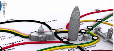
The map was created using CASA's free Image Cutter software, which helps create maps from any image.
This tube map doesn't include any real-time tracking of trains or fancy search facilities, in fact it isn't actually much use in helping you find underground train stations. In this instance it is a case of being just a pretty face.
Via googlemapsmania
26. märts 2008
Map portals in Latvia
There're three main local players in Latvian internet-mapping market:
Jana Seta: best quality and coverage of maps and addresses, operating mainly raster images not GIS databases, limited software functionalities.
See demo here
BOD and Datorkarte: good map scales but not the best coverage, quality and updatedness, many additional layers, limited software functionalities.
See demos here
Envirotech (H-Nit daughter-company): local ESRI reseller, available ArcGIS server functionalites, not active in public internet market, state owned data:
See demo here
20. dets 2007
Joystick again
Joystick may give quite good control over map moving or pan: direction, extent and speed. Try MyMiniCity navigation and see also previous post at the same topic here...

2. nov 2007
Move Mis-Marked Addresses in Google Maps
Ever look up an address on Google Maps and find that the pushpin for that address is more than a bit off? Now you can edit where Google pinpoints addresses (provided you're logged into your Google account) by clicking the Edit link and dragging the pin to a more appropriate location.
Via LifeHacker
Via LifeHacker
24. okt 2007
Cool idea for real-estate portals
Great idea that is possible to gain easily through our MapCat API either :-)

12. juuli 2007
Nutimap beta
Now you can download and test Nutimap interactive mobile map application. It has Regio detailed maps and address data, MGMaps.com application.
It supports:
- Regio most detailed Estonian maps (up to house number level)
- Search for addresses and placenames in Estonia (also up to house numbers)
Other key features:
- Track your location using GPS (via Bluetooth)
- Save your favourite locations
To be done yet:
- Search objects (POI) around some place
- Route directions
- million other extension ideas...
3. juuli 2007
Routing on the fly
21. juuni 2007
Is it allowed?
Many customers have asked, is it possible to use Google free API for applications like SeeMe launched lately. The answer is: NO, IT'S NOT ALLOWED! License says: "Except where you have been specifically licensed to do so by Google, you may not use Google Maps with any products, systems, or applications installed or otherwise connected to or in communication with vehicles, capable of vehicle navigation, positioning, dispatch, real time route guidance, fleet management or similar applications".
See also additional terms of Google API:
…Service may not be used: (a) for or with real time route guidance (including without limitation, turn-by-turn route guidance and other routing that is enabled through the use of a sensor), or (b) for, or in connection with, any systems or functions for automatic or autonomous control of vehicle behavior.
First application from our competitor in paper maps market
We have waited for years when the day comes our competitor in paper maps market starts to serve internet maps and build webmap applications. The day has come!
True, the first application is rather example of how a map application should not be built on 21th century. It's good illustration of architecture we tried to avoid starting development of MapCat SDK years ago (use together with LiveHTTPheaders sidebar). Still, it works somehow regardless some serious usability issues and probably next version will already be better. Potential competitor in Estonian market for some years and I hope it makes us stronger also :-) Worth to be blogged!

True, the first application is rather example of how a map application should not be built on 21th century. It's good illustration of architecture we tried to avoid starting development of MapCat SDK years ago (use together with LiveHTTPheaders sidebar). Still, it works somehow regardless some serious usability issues and probably next version will already be better. Potential competitor in Estonian market for some years and I hope it makes us stronger also :-) Worth to be blogged!
24. mai 2007
Future of routing services?
Movin 360 Berlin tour recalls a city journey on a map and a 360 degree panorama- video. Camera viewpoint can be changed on video screen.
The development of map.movin360 is thesis (diploma) work of Christian Müllenhagen and Fabian Zastrow during wintersemester 2006/2007 at Technischen Fachhochschule Berlin. More in German...
The development of map.movin360 is thesis (diploma) work of Christian Müllenhagen and Fabian Zastrow during wintersemester 2006/2007 at Technischen Fachhochschule Berlin. More in German...
Tellimine:
Postitused (Atom)