Kuvatud on postitused sildiga MapCat Medium. Kuva kõik postitused

1. juuli 2008

Interactive tourism-map (KOV)

There is new map on our products line. Interactive tourism-map (oftentimes called KOV inside Regio) is a tool for local municipalities, tourism portals etc to promote POI-s, hiking-routes, nature parks etc on map. It has features like route calculation, intelligent address-search, multible map views, emailing and printing map.

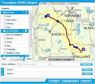
Even more noteworthy are its administration possibilities: Administrator can customize whole map interface design, its measures, and behaviour of objects, depth of zoom levels etc. Of course, has total control over object (
also upload pictures to POI-s), layer and groups management.


Try our public demo account:
Map: http://teenus.regio.ee/kov/index.php?id=199
Admin: http://teenus.regio.ee/kov/admin
User: „demo“
Pass:
„demo123“
NB! User rights in demo are limited.


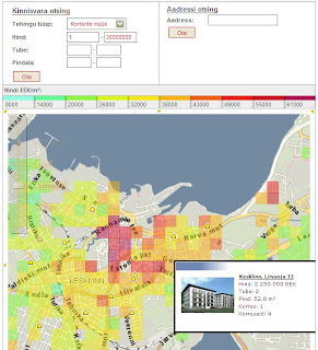
Examples of projects using KOV:
- Map of
MTÜ Pandivere Arendus-ja Inkubatsioonikeskus
-
Map of Põlvamaa talurahvamuuseum. More about this project
- With interface using
special design.


Baltic maps

Our own map and geocoding database of Baltics is finally ready and first tileset with address search is online for testing. Links to map demos:
Latvia
Lihtuania

24. jaan 2008

QVIZ prototype 2

QVIZ new prototype has been integrated to faceted search lately: narrow your search results using map as a filter or determine time-period using time-bar component:

23. jaan 2008

Travel Planning wizard

During last couple of month we've had great chance to cooperate with Affecto and develop TravelPlan map-wizard for a finnish tourism portal. Application uses maps, geocoding and routing services from GeniMapper platform (Affecto's mapserver service for Finland) and is built up using MapCat Medium software.

21. jaan 2008

Newly discovered old one

Map for Biological Diversity web-page. NB! It was developed as early as 2004 (wasn't common approach then technically) and wasn't in active use couple of years but now it's quite living its own life :-)

19. nov 2007

Estonian Forest Registry in web

Estonian Forest Registry is finally accessible through web. New and attractive web-site will be released soon in cooperation with Regio webmap team (us :-) and Centre of Forest Protection and Silviculture.

8. nov 2007

New era in MapCat development

Map application for biggest internet portal in Baltics (Delfi) that brings us to new era is finally ready:


- try new drag'n'drop layer menu: order of layers is saved in cookies so you can personalize your menu, also the sequence of displaying symbols on top of the map is influenced by layers order.
- animated zoom: map is moving towards search results visualizing the access to an address, location or route.
- map navigation by using keyboard: pan, zoom in and out using just 'arrow' keys.
- search options and driving guidance: show all results as a list or use map bbox for filtering results; show all search-list items or line segments on the map and highlight them both on map or search-list.
- draw your own map and send it to your friend or save in your blog, web-site etc.
- ...and many-many more!

Application for Delfi is first customer project implemented by using technology developed within R&D project named GISSER funded by Enterprise Estonia.

6. nov 2007

KV real-estate chorophlet map

Estonian real-estate portal KV launched their new map search based on our MapCat Medium component. When choosing a deal type and parameters like price, number of rooms etc, map will be covered with vector layers of average m² price and property objects corresponding to the search preconditions. Useful tool for finding property via map.

23. apr 2007

Thematic map for QVIZ

This is our first prototype for QVIZ - map application capable of drawing thematic maps about time-spatial distribution of digitized historical documents. Polygon color refers to amount of items (historical resources) within search result. Developers can use map as a search filter/faceted query component (specify search by map parameters: bounding box, selected ploygon etc).

15. märts 2007

Estonian Breeding Bird Atlas

New version of Estonian Breeding Bird Atlas based on MapCat Medium and flashtile technology. Nowadays birdwatch and data collecting is based on 5x5 km UTM squares but as 10x10 had been used before 2003 then follow-up project is planned before 2010 (end of the project). The aim of this project is to make those data comparable (generalization of data collected based on 5x5 will be done). Today only data collected 2003 and later is published.

Direct link to english version here