Cairolocator - Interactive web mapping solution covers Cairo with detailed maps .It allows users to search in more than 5000 pos and streets.cairolocator is the first web map application supports Arabic.
FlashNavigator - Demonstration of flashNavigator technology. Using powerful Flash map engine flashNavigator is able to display GIS and CAD file formats in Flash viewer. This world map was created using ESRI Shapefile source. Map is divided into 7 layers and it can be fast panned and zoomed. Also there is statistical GIS analysis available. Map is colored in real time to display results of analysis. There is an option to test your own SQL queries and see results on map.
DynaWebMap - DynaWebMap provides a powerful server side map web control which integrates with gViewTek's vector maps library. Users can select their own interesting maps and connect their own data, such as demographic data or other statistics data through data binding fields. DynaWebMap map web control provides wonderful vector map with professional map operations and dockable map components, such as toolbars, overview map, dynamic legend, and charts. DynaWebMap allows users and developers to easily create, display the dynamic web-based vector map, and chart through a group of simple code inside the web pages or behind the web pages.
More from Directions Magazine's web map gallery
9. okt 2007

2. okt 2007
New GUI for tourism applications
As a result of GISSER (one of our R&D projects funded by Enterprise Estonia) new release of our tourism map-applications will be launched next week. First customer using upgraded technology and advanced GUI will be the biggest Estonian internet portal Delfi (see application under construction here).
Application is built based MapCat technology and attractive GUI for tourism-like type of applications is designed in cooperation with Webmedia design division. Long-term objective of this cooperation was to elaborate GUI traits characteristic to all our webmap applications including MapCat API.

Application is built based MapCat technology and attractive GUI for tourism-like type of applications is designed in cooperation with Webmedia design division. Long-term objective of this cooperation was to elaborate GUI traits characteristic to all our webmap applications including MapCat API.
26. sept 2007
Newsletter about ASP services and data updates
We started to send newsletter to our customers (only in estonian). Main motivator of doing this was need for updated information about our services and data updates, but also software upgrades and latest customer projects.
Regio runs biggest masperver in Baltics and more than 100 applications are using our ASP services daily. See newsletter archive in blog and also latest release about map updates here
Regio runs biggest masperver in Baltics and more than 100 applications are using our ASP services daily. See newsletter archive in blog and also latest release about map updates here
17. sept 2007
From Google Maps directly to your Mercedes Benz
Mercedes-Benz has recently included a Google Maps service for drivers called Search & Send. The service will give Mercedes-Benz drivers who are equipped with Tele Aid the ability to send destinations and searches directly from Google Maps. More from Google Maps Mania blog...
13. sept 2007
Merge Your Map on Yahoo Maps with MapMixer
Yahoo launches new webapp MapMixer, which blends an existing map image with Yahoo Maps. Handy for overlaying a static public transportation system, campus or hiking trails map onto a fancy-pants dynamic Ajax map, MapMixer's essentially an easy-peasy mashup maker for anyone with a map digital image (or a scanner). Just upload your image and fit it onto Yahoo Maps.

Check out some more MapMixer creations in the featured map gallery.
7. sept 2007
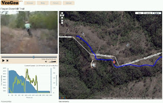
Video playpack syncronised on map
VeoGeo is a community based mashup using user GPS data, user video from YouTube and Google maps to playback video in sync with GPS data on Google map.
The mashup is still in early Beta, but working with existing examples very well.
This kind of mashups may have a lot of potential in tourism industry and others, especially when cellphones will have good GPS (A-GPS) support.
veogeo.com
The mashup is still in early Beta, but working with existing examples very well.
This kind of mashups may have a lot of potential in tourism industry and others, especially when cellphones will have good GPS (A-GPS) support.
veogeo.com

17. aug 2007
JavaScript Map API comparison
Look at comparison of performance and developer friendliness of JavaScript mapping APIs by Niall Kennedy here...
See also Mapstraction.com website (library that provides a common API for various javascript mapping APIs to enable switching from one to another) and demos.

13. juuli 2007
Papervision3D Public Beta
Papervision is 3D engine released under the MIT Open Source litsense:
...It started as a simple way to transform MovieClips to achieve the 3D illusion. By changing their position, size, rotation and skew you could almost forgive the lack of perspective. But the latest version, fully optimised for Flash 8 Image API, uses triangle tesselation to distort textures. Now we can render complex objects in “real 3D”!

Read also Adobe's article" Mapping Flash video to 3D objects".
...It started as a simple way to transform MovieClips to achieve the 3D illusion. By changing their position, size, rotation and skew you could almost forgive the lack of perspective. But the latest version, fully optimised for Flash 8 Image API, uses triangle tesselation to distort textures. Now we can render complex objects in “real 3D”!
Read also Adobe's article" Mapping Flash video to 3D objects".
12. juuli 2007
Nutimap beta
Now you can download and test Nutimap interactive mobile map application. It has Regio detailed maps and address data, MGMaps.com application.
It supports:
- Regio most detailed Estonian maps (up to house number level)
- Search for addresses and placenames in Estonia (also up to house numbers)
Other key features:
- Track your location using GPS (via Bluetooth)
- Save your favourite locations
To be done yet:
- Search objects (POI) around some place
- Route directions
- million other extension ideas...
It supports:
- Regio most detailed Estonian maps (up to house number level)
- Search for addresses and placenames in Estonia (also up to house numbers)
Other key features:
- Track your location using GPS (via Bluetooth)
- Save your favourite locations
To be done yet:
- Search objects (POI) around some place
- Route directions
- million other extension ideas...
3. juuli 2007
Routing on the fly
Tellimine:
Postitused (Atom)