
20. dets 2007
Joystick again
Joystick may give quite good control over map moving or pan: direction, extent and speed. Try MyMiniCity navigation and see also previous post at the same topic here...
19. nov 2007
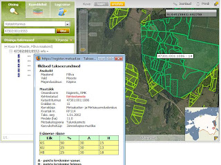
Estonian Forest Registry in web
Estonian Forest Registry is finally accessible through web. New and attractive web-site will be released soon in cooperation with Regio webmap team (us :-) and Centre of Forest Protection and Silviculture.
8. nov 2007
New era in MapCat development
Map application for biggest internet portal in Baltics (Delfi) that brings us to new era is finally ready:
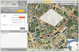
- try new drag'n'drop layer menu: order of layers is saved in cookies so you can personalize your menu, also the sequence of displaying symbols on top of the map is influenced by layers order.
- animated zoom: map is moving towards search results visualizing the access to an address, location or route.
- map navigation by using keyboard: pan, zoom in and out using just 'arrow' keys.
- search options and driving guidance: show all results as a list or use map bbox for filtering results; show all search-list items or line segments on the map and highlight them both on map or search-list.
- draw your own map and send it to your friend or save in your blog, web-site etc.
- ...and many-many more!
Application for Delfi is first customer project implemented by using technology developed within R&D project named GISSER funded by Enterprise Estonia.
6. nov 2007
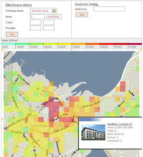
KV real-estate chorophlet map
Estonian real-estate portal KV launched their new map search based on our MapCat Medium component. When choosing a deal type and parameters like price, number of rooms etc, map will be covered with vector layers of average m² price and property objects corresponding to the search preconditions. Useful tool for finding property via map.
2. nov 2007
Move Mis-Marked Addresses in Google Maps
Ever look up an address on Google Maps and find that the pushpin for that address is more than a bit off? Now you can edit where Google pinpoints addresses (provided you're logged into your Google account) by clicking the Edit link and dragging the pin to a more appropriate location.
Via LifeHacker
Via LifeHacker
24. okt 2007
Cool idea for real-estate portals
Great idea that is possible to gain easily through our MapCat API either :-)

9. okt 2007
Some cool web-maps
Cairolocator - Interactive web mapping solution covers Cairo with detailed maps .It allows users to search in more than 5000 pos and streets.cairolocator is the first web map application supports Arabic.
FlashNavigator - Demonstration of flashNavigator technology. Using powerful Flash map engine flashNavigator is able to display GIS and CAD file formats in Flash viewer. This world map was created using ESRI Shapefile source. Map is divided into 7 layers and it can be fast panned and zoomed. Also there is statistical GIS analysis available. Map is colored in real time to display results of analysis. There is an option to test your own SQL queries and see results on map.
DynaWebMap - DynaWebMap provides a powerful server side map web control which integrates with gViewTek's vector maps library. Users can select their own interesting maps and connect their own data, such as demographic data or other statistics data through data binding fields. DynaWebMap map web control provides wonderful vector map with professional map operations and dockable map components, such as toolbars, overview map, dynamic legend, and charts. DynaWebMap allows users and developers to easily create, display the dynamic web-based vector map, and chart through a group of simple code inside the web pages or behind the web pages.
More from Directions Magazine's web map gallery
2. okt 2007
New GUI for tourism applications
As a result of GISSER (one of our R&D projects funded by Enterprise Estonia) new release of our tourism map-applications will be launched next week. First customer using upgraded technology and advanced GUI will be the biggest Estonian internet portal Delfi (see application under construction here).
Application is built based MapCat technology and attractive GUI for tourism-like type of applications is designed in cooperation with Webmedia design division. Long-term objective of this cooperation was to elaborate GUI traits characteristic to all our webmap applications including MapCat API.

Application is built based MapCat technology and attractive GUI for tourism-like type of applications is designed in cooperation with Webmedia design division. Long-term objective of this cooperation was to elaborate GUI traits characteristic to all our webmap applications including MapCat API.
26. sept 2007
Newsletter about ASP services and data updates
We started to send newsletter to our customers (only in estonian). Main motivator of doing this was need for updated information about our services and data updates, but also software upgrades and latest customer projects.
Regio runs biggest masperver in Baltics and more than 100 applications are using our ASP services daily. See newsletter archive in blog and also latest release about map updates here
Regio runs biggest masperver in Baltics and more than 100 applications are using our ASP services daily. See newsletter archive in blog and also latest release about map updates here
17. sept 2007
From Google Maps directly to your Mercedes Benz
Mercedes-Benz has recently included a Google Maps service for drivers called Search & Send. The service will give Mercedes-Benz drivers who are equipped with Tele Aid the ability to send destinations and searches directly from Google Maps. More from Google Maps Mania blog...
Tellimine:
Postitused (Atom)